Time Zones
4.15 - Understand the difference in local time for observers at different longitudes4.16 - Understand the use of time zones
The Earth rotates and the Sun will be at the highest point of the sky from any location at that points solar time but at a different location this will occur later or earlier. If you move 1 degree of longitude either way the Sun will culminate at midday but your midday will be 4 minutes earlier or later than your previous location. How we measure time is a human invention based on astronomy.
A brief history of time standards is needed.
Back in the day, before powered transport or telecommunications, every town or village would set it's clocks by the Sun. A problem arose when trains were invented. People would find themselves losing and gaining time when they reached their destination. They didn't really lose or gain time though; they had to reset their watches and clocks. When the telegraph was invented messages were sent at times later than the receiver got them, like if you were sent an email with tomorrows date on it.
The introduction of Time Zones was brought in to help this human problem.
Britain decided to have one time throughout the country. Britain would use the apparent solar time based at Greenwich Royal Observatory in London as the mean solar time. This meant if apparent solar time (AST) in London was 12pm midday, in Bristol it would be 11.56am (AST). Bristol would use London time for its clocks and watches. This meant timetables for trains and telegraphic equipment were accurate nationally. Other countries adopted this. Some countries were bigger than others such as Russia, Canada and America. One time zone would not be logical. If the USA had one time zone, it might be solar midday 12pm in New York but solar midday at San Francisco at 8am.
Once the telegraph was used in the 19th century, countries realised they needed to agree on time. They needed a longitude starting point from which to measure time. The prime meridian was decided to be based in Greenwich. There were two good reasons for this; the Royal Observatory was the leading centre for astronomical observations and most maps of the sea and navigational almanacs at the time were based on Greenwich.
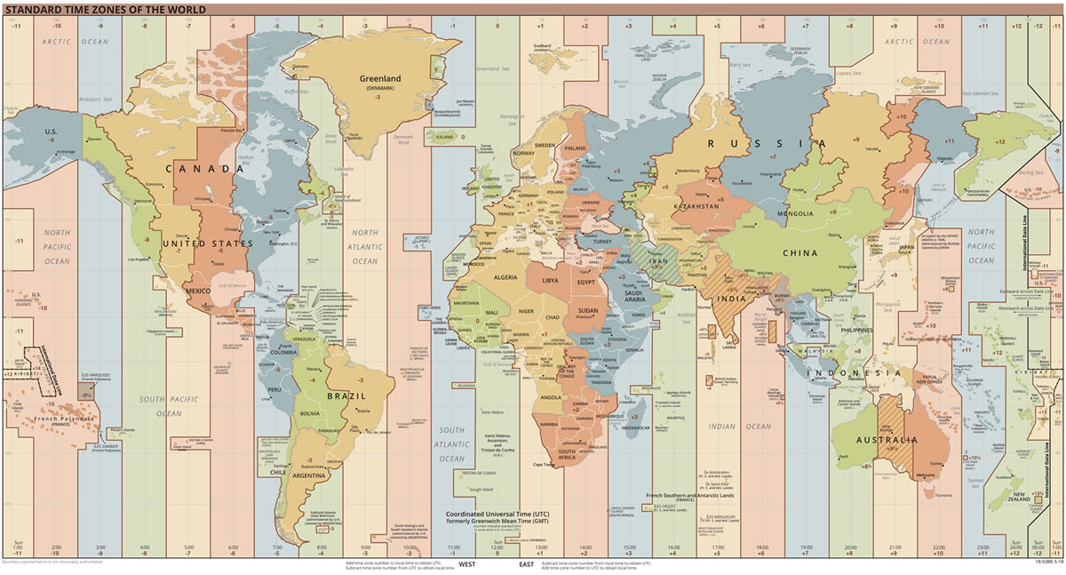
How they work
The world is split into 24 meridians at 15° apart. The zones represent 1 hour. If you move from one zone to another you must change your watch to one hour in front or behind, depending on which way you were going. If you went north or south you would not need to adjust your time.
Some regions or countries adopt the system differently so sometimes they have a half hour difference. The lines do not cut through countries, some territories adopted the system to include or exclude regions.
The international date line is the 180° line of meridian of longitude that runs form the north pole to the south pole via the pacific ocean. It is on the opposite side of earth from the Greenwich meridian. If you moved over it from east to west you would lose a day, while if you travelled over it from west to east you would gain a day. You would not notice any difference in the surroundings or in life; this date line is a human invention.
Downloads
Links
- World Time Zone Times for all over the world
- Greenwich Mean Time A History of Time Zones
- Royal Observatory, Greenwich Official Site
 | © All Rights Reserved |